That moment when you grew up in rural Canada and you see someone on a US show claiming that Alaska is “the last real wilderness in North America” and end up contemplating how he just literally doesn’t know that 60% of the area of your country exists.
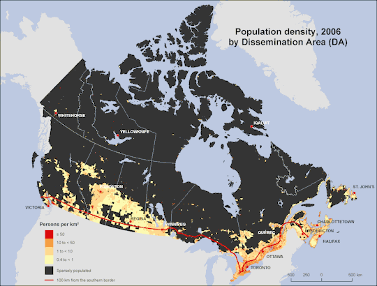
The usual vague stat is that 75% of us live within 100 miles of the US border.
There are about 35 million Canadians. 6 million (approx) live in Toronto; 4 million (approx) live in Montreal; 2.5 million (approx) live here in Vancouver (if you properly count our whole metro area, rather than being kind of weird and actually just counting the south-side Vancouvers which a different set of numbers on wiki does, because they’re weird, so don’t be misled if you look there); and 1.3 million (approx) live in Calgary, Ottawa-Gatineau and Edmonton each.
Toronto, Montreal and Vancouver are The Big Cities (yes I know, stop laughing) of Canada, and we make up 12.5 million out of 35 million total – something over a third. When you’re generous and add Calgary, Ottawa and Edmonton, the top six cities contain approaching 17 million, which is half of our population.
Of the next six largest cities, however? Four of them are in Ontario. (Kitchener, Hamilton-Waterloo, St Catharines-Niagra, and London; the other two are Winnipeg and Quebec City). So that puts Toronto, Ottawa, and these four in Ontario. They are all within relatively short distance, compared to the rest of the country, of Toronto. So in some senses, yeah, most of us live SOMEWHERE around Toronto, which is why Toronto gets convinced it’s the centre of the universe and gets so annoying the rest of us want to burn it down. (Especially the other Ontarians.)
While I’m at it, exactly half of the population of Manitoba lives in Winnipeg. Not even in all the towns and cities AROUND Winnipeg, not in the southernmost fifth of Manitoba: in Winnipeg.
So yeah. For anyone wondering, I grew up up in the second-most northerly cluster of pale yellow in BC. I now live in Vancouver.
In closing I will share my favourite population of Canada fact: the population density of the NWT is officially zero. Now, slightly more than 40K people live in the NWT? But that means that compared to the territory involved, there are fewer than 0.1 of them per square km. Their population density is officially zero. XDXD
My home province, Saskatchewan (the big rectangle in the middle of the map), has an average population density of just under 2 people per square km, and about 1.1 million people total. About half of those people live in either Regina or Saskatoon.
We get unreasonably excited every time the census shows our population has grown. I’m pretty sure there was a party when we passed a million people about a decade ago.
After the Romans departed, systematic construction of paved highways in the UK did not resume until the early 18th century. The Roman road network remained the only nationally-managed highway system within Britain until the establishment of the Ministry of Transport in the early 20th century. (Source)
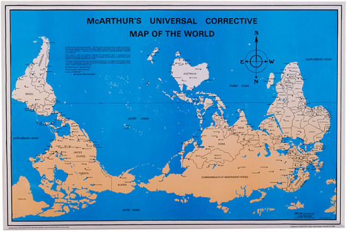
do most american world maps seriously have america in the centre?
WE DO HAHAHAHA
Are you fucking kidding me.
In Chinese maps, Asia is in the center. Which nation is centralized depends on the map’s origins.
In Canada, our maps are cut through the Pacific, so we don’t offend anyone.
sometimes i feel like canadian stereotypes go too far and then this happens
Australian maps are upside down so Australia is above everyone else
you think this is a joke
are you fucking serious
What? I live im America & I don’t think I’ve ever seen a map like that before this. Most world maps I’ve seen are either cut at the Prime Meridian or they have Europe at their center.


You must be logged in to post a comment.