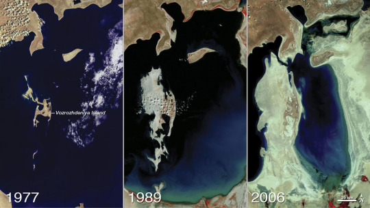
The Aral Sea was once the
fourth-largest lake in the world. Fed primarily by snowmelt and precipitation
flowing down from faraway mountains, it was a temperate oasis in an arid
region. But in the 1960s, the Soviet Union diverted two major rivers to
irrigate farmland, cutting off the inland sea from its source. As the Aral Sea
dried up, fisheries collapsed, as did the communities that depended on them.
The remaining water supply became increasingly salty and polluted with runoff
from agricultural plots. Loss of the Aral Sea’s water influenced regional
climate, making the winters even colder and the summers much hotter.
While seasonal rains still
bring water to the Aral Sea, the lake is roughly one-tenth of its original size.
These satellite images show how the Aral Sea and its surrounding landscape has
changed over the past few decades.
The beautiful Blanktjärnarna. Jämtland, Sweden. The water is extremely clear but coloured green by limestone/kalksten. It’s magical to see, like stepping into a fairytale.


You must be logged in to post a comment.